There are a number of caminos reales (royal paths) on Gran Canaria. The name bewilders rather than clarifies, as they were used historically by farmers using donkey and cart or pilgrims progressing on foot to a holy place rather than by kings and queens. One of these hiking routes to try follows the Barranco de Azuaje (Azuaje ravine).
The Barranco de Azuaje: getting there

In suburbia, you will find ravines. That is the case in Gran Canaria, at any rate. As I've previously covered in a two-part guide to hiking the Barranco de Guiniguada.
This time, however, I was walking along the ravine which starts a little further away than where I live. Global run a direct bus service from Las Palmas de Gran Canaria's Parque San Telmo bus station to Firgas central, the 201. However, it's an irregular one and because of the time (UK early evening/GC afternoon) I was travelling, I first took the 206 to Arucas (single fare €2,30) before completing my journey on the 211 (single fare €1,40).
The Azuaje ravine, what's in a name?

The Barranco de Azuaje takes its name from two sugar daddies, Damián and Francisco de Azuaje. They were Genoese merchants who relocated to Gran Canaria from Italy in the 15th century. Exporting the sweet stuff from GC to the mainland by way of Cadiz.
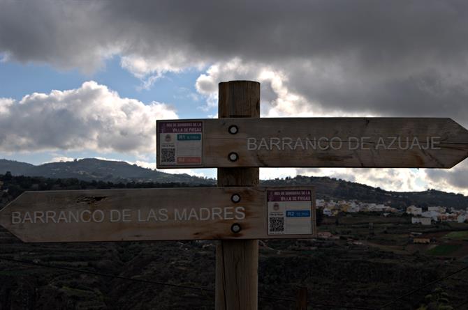
The Barranco de Azuaje, following the signs

Whichever you turn, left or right, you'll be following the same ravine. Don't get confused. The section I walked, down to San Andrés is known as the Barranco de Azuaje, which is the name of the ravine in full too, whilst further up it's called the Barranco de las Madres.
Its pre-Spanish name was Agumastel, however. Other parts of it are referred to, variously as Barranco de Guadalupe, de la Virgen, del Andén, and de Crespo. Lower down, it's aka the Barranco de San Andrés.
Handy hints and tips for hiking the Barranco de Azuaje

As with any other hike on the island, be prepared. So types someone who once had to negotiate the final descent to Güigüi sliding down on his rear. As he'd neglected to bring a torch, and the sun had gone down quicker than he'd anticipated.
Take water with you and protect yourself from the sun, particularly in summer months. Don't assume the path will always be smooth and easy to follow. At the start, it seemed to end in a local resident's vegetable patch until a goat farmer reliably informed me that it actually continued.
The 45-minute descent which is signposted as La Capellanía is by the most taxing part of the hike, because it's so steep. At the bottom, you'll reach the ruins of the Hotel Balneario de Azuaje, a pioneering tourist development which was built in 1868. This spa hotel was set up to accommodate health tourists from northern Europe who had heard of the healing properties of Firgas water, although it was also popular with honeymooning locals.
You'll know you've reached the end of the hike when you see the more-porous-than-normal nets of the goals at San Andrés' abandoned football pitch. Above you'll see the GC-2 and beyond the Atlantic Ocean. From here, I returned to Las Palmas de Gran Canaria on the 116 (single fare €2), roughly two hours after beginning this walk in Firgas.
